

Hurricane Melissa made landfall on the Caribbean island of Jamaica on Tuesday afternoon, October 28.
From their orbital vantage points, satellites are meticulously tracking the formidable Hurricane Melissa as it bears down on Jamaica.
Monitoring of Hurricane Melissa, the 13th named storm of the Atlantic Hurricane season, began on October 21. Within a rapid four-day period following its initial development, the storm intensified dramatically. By early Monday, October 27, Melissa had escalated into a colossal and perilous major hurricane on the Saffir-Simpson Hurricane Wind Scale, exhibiting sustained winds reaching an astonishing 175 miles per hour (280 kilometers per hour).
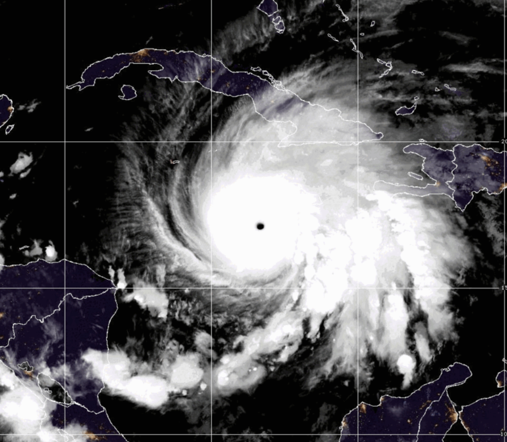
Currently classified as a formidable Category 5 storm, Hurricane Melissa poses an exceptionally destructive threat due to its agonizingly slow forward momentum. Its recent landfall in Jamaica marked a grim milestone, as Melissa became the most powerful hurricane to ever strike the island nation in its recorded history.
This unprecedented event stands in stark contrast to past occurrences. Data from the National Oceanic and Atmospheric Administration (NOAA) reveals a scarcity of comparable landfalls: since 1950, only three hurricanes, including Melissa, have made landfall on the island. Of these, the two previous storms were Category 3 hurricanes: Hurricane Charlie in 1951, followed by Hurricane Gilbert in 1988, both significantly less intense than the current tempest.
Orbiting satellites provide essential capabilities for scientists and forecasters, allowing them to precisely monitor a storm’s progression, tracking its path and observing its growth in both size and strength from formation to dissipation. Specifically, the National Oceanic and Atmospheric Administration’s (NOAA) Geostationary Operational Environmental Satellite (GOES) system has maintained a vigilant, high-definition observation of Hurricane Melissa since its genesis, furnishing critical data on its evolution.
Leveraging its advanced suite of instruments, the GOES-19 satellite provides meteorologists with crucial insights into the intricate dynamics of storms. This capability allows experts to precisely track lightning within a storm’s eye, pinpoint the critical moment of its rapid intensification, and accurately map the extent of its far-reaching outer bands.

Satellite observations offered crucial insights into the storm’s evolution, revealing its increasing symmetry as it intensified across the open Caribbean Sea. The data also pinpointed the precise moment and location where the system dramatically slowed, beginning its deliberate, measured trajectory towards Jamaica.
The approaching weather system is expected to unleash life-threatening flash flooding, dangerous landslides, and potentially devastating winds across the island until Tuesday, October 28. Its projected path over the Dominican Republic and Haiti is anticipated to bring similar severe conditions, persisting through the middle of the week.
For the most current and authoritative information regarding Melissa, consult NOAA’s National Hurricane Center.